Recent Storm Damage Posts
Storm Preparation Tips for the East Boston Community | SERVPRO of East Boston, Chelsea & Revere
2/17/2024 (Permalink)
 Is your home experiencing the devastating aftermath of a storm? We are here to help. Contact SERVPRO of East Boston, Chelsea & Revere today!
We sure are no strangers to storms in the Boston area! Hot and muggy summers can bring rainstorms, cold and unpredictable winters can bring snow (and some years, no snow at all) and the fall season can bring coastal storms and even hurricanes our way.
There is no shortage of weather threats in our community. That said, preparing for all of these scenarios is crucial to help reduce your risk of suffering home damage and to keep your family safe.
Preparing both the inside and outside your home ahead of any severe weather can help you stay in control and navigate the situation with confidence.
Preparing the Outside of Your Home
If you own your own home, chances are that you already have a list of maintenance tasks that you tackle seasonally to get your home ready for every change and time of the year. The good news is that a lot of what you do on a regular basis is helpful when it comes to preparing for storms.
Things like trimming dead branches and limbs from your trees, picking up yard debris and cleaning out your gutters help remove potential threats from your property. Clean gutters ensure that any rain we get will flow safely down and away from your home.
If a coastal storm or hurricane is headed our way, you should focus on sealing all of the entry points into your home. Close your hurricane or storm shutters, inspect your roof for any signs of damage and repair damage immediately, and ensure all of the seals around your doors and windows are clean and not deteriorating.
Tie down anything that cannot be moved inside, and consider adding bracing to your sheds or roof reinforcements to protect them from damage.
Preparing Inside Your Home
We deal with a good deal of precipitation when storms come our way, so a lot of preparation inside your home is going to center around mitigating flood risk. Get important documents and papers off of the floor or lowest levels of your home, move any keepsakes or memorabilia to a safe location, and consider shutting off electricity to your basement if it is known to flood during a heavy rain or hurricane.
Prepare your emergency kit, update any emergency contacts and charge your phone. Losing power is frustrating, but losing power and having no way to communicate with family or authorities is another issue!
What to Do After the Storm
Storms can cause significant damage in a short amount of time. Do your best to stay calm, and move cautiously about your home after the weather threat has passed. If your home has suffered severe damage, consider getting outside and staying away from your home until authorities have inspected it and deemed it safe to re-enter.
As soon as you are cleared to call us, give us a ring and we will start working with you on your restoration plan. We will get out to your home quickly and do everything necessary to help you fully recover. We will extract standing water, address water and storm damage and reconstruct any part of your home that was damaged by the elements.
Don’t be caught off-guard by a storm! Contact us at SERVPRO of East Boston, Chelsea & Revere for immediate restoration assistance.
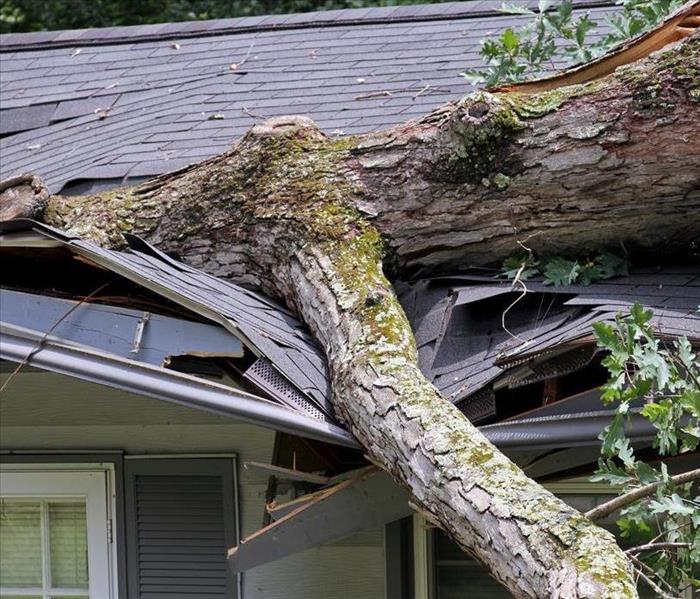
Your roof and storm damage prevention
9/24/2020 (Permalink)
 Wind damage can be just as devastating as flood damage. Inspect your roof and use the best materials you can afford
Certain home shapes and roof types can better resist high winds and hurricanes, according to a researcher at New Jersey Institute of Technology (NJIT). Civil engineer Rima Taher, PhD, special lecturer in the New Jersey School of Architecture at NJIT. She spent two years examining the findings of research centers that have studied the best designs and construction materials and methods needed to withstand extreme wind events and hurricanes.
"Although I'd like to say that there is a simple and economical solution for housing that won't fail or collapse in the perfect storm, such information does not yet exist," said Taher. "However, it is obvious that thanks to the work of wind engineers and researchers that changes to home design and construction can make buildings safer for people, while saving government and industry billions of dollars annually."
"Design of Low-Rise Buildings for Extreme Wind Events" (Journal of Architectural Engineering, March, 2007) by Taher highlighted such research findings. Wind researchers at the Center for Building Science and Technology (CSTB) in France, researched and tested reduced-scale home models at its wind tunnel facilities, and developed a prototype of a "cyclonic" or hurricane-resistant dwelling. Taher cooperated with the CSTB wind researchers, working on the structural aspect of the home's design.
That design eventually became an elevated structure of a square plan form on an open foundation. The home had a hip roof and was equipped with a central shaft with aerodynamic features designed to reduce wind forces during an extreme wind event. Wind tunnel tests at CSTB showed that such a home would be far more efficient under high winds and hurricane conditions than a typical structure. CSTB is working with a builder to construct a prototype of such a home on Réunion in the West Indian Ocean.
From this work and other studies Taher recommends the following construction considerations for homeowners in hurricane-prone regions.
- A home with a square floor plan (or better a hexagonal or octagonal plan) with a multiple-panel roof (4 or more panels) was found to have reduced wind loads.
- Roofs with multiple slopes such as a hip roof (4 slopes) perform better under wind forces than gable roofs (2 slopes). Gable roofs are generally more common because they are cheaper to build. A 30-degree roof slope has the best results.
- Wind forces on a roof tend to be uplift forces. This explains why roofs are often blown off during an extreme wind event. Connecting roofs to walls matters. Stapled roofs were banned following Hurricane Andrew in Florida in 1993.
- Strong connections between the structure and its foundation and connections between walls are good. Structural failure is often progressive where the failure of one structural element triggers the failure of another, leading to a total collapse. Connections are generally vulnerable but can be inexpensively strengthened.
- Certain areas of a building such as the ridge of a roof, corners and eaves are normally subject to higher wind pressures. In the cyclonic home design, CSTB researchers proposed some aerodynamic features to alleviate these local pressures such as introducing a central shaft which would function by creating a connection between the internal space and the roof ridge considered to be the location of the largest depression. This connection helps balance pressures leading to a significant reduction in the roof's wind loads.
- Roof overhangs are subject to wind uplift forces which could trigger a roof failure. In the design of the hurricane-resistant home, the length of these overhangs should be limited to 20 inches.
- The design of the cyclonic home includes simple systems to reduce the local wind stresses at the roof's lower edges such as a notched frieze or a horizontal grid to be installed at the level of the gutters along the perimeter of the home.
- An elevated structure on an open foundation reduces the risk of damage from flooding and storm-driven water
Not only does the shape of the roof need to be taken into account but so to the material that it is made out of. We will also take a look at the roofing materials available along with the relative costs for them.
Asphalt Roll Roof
Asphalt roll roofing is made from large rolls of the same material used in asphalt shingles. Used for relatively flat pitches, such as angled shed roofs, roll roofing is installing by laying strips lengthwise across the roof in overlapping courses. Roll roofing is a fairly easy material to install, and many DIYers do this themselves. But it is better suited for sheds, garages, and perhaps porch roofs, and is not a very good solution for most home roofs.
Average Lifespan
Asphalt roll roofing can be expected to last from 5 to 10 years, at most. Getting maximum life from the roofing is really just a matter of keeping it clear of debris and quickly patching any punctures or damage that occurs.
Installation Costs and Lifetime Value
Asphalt roll roofing is normally installed on roofs with a relatively flat peak, so a 2,000 square foot house will have very close to 2,000 square feet of roof area. Average costs for installing this roof are about $2.25 per square foot, for a total average cost of roughly $4,500. But assuming that this roof will likely need to be replaced perhaps 12 times over 100 years, total costs over this period, in today's dollars, can be as high as $54,000 over 100 years.
Built-Up Roofing (BUR)
A built-up roof (BUR) is a layered roof that is created by alternating layers of roofing felt and waterproof materials such as fiberglass, and hot tar (bitumen). Normally used on roofs that are flat or with a very slight pitch, BUR roof. It is fire-resistant and inexpensive, but the roofing is messy and smelly to install.
Average Lifespan
BUR roofs typically last from 20 to 30 years. Maximizing the lifespan of a built-up roof is accomplished by regular inspection and repair, and by keeping debris off the roof to prevent degradation of the surface.
Installation Costs and Lifetime Value
Built-up roofing average about $4 per square foot, installed. On a 2,000 square foot house with a roof very close to that square footage, average professional installation costs about $8,000. Assuming that this roof will need to be replaced about four times over a 100 year period, average roofing costs in today's dollars are about $32,000 over 100 years. However, this type of roof is not suitable for a home with any real slope to the roof.
Composite Asphalt Shingle Roof
Composite shingle roofing is the most popular of all roofing materials, found on more than 80 percent of all homes. Composite shingles use either an organic or fiberglass base that is saturated with asphalt, coated on the bottom side with asphalt, and the exposed surface impregnated with small chips of slate, schist, quartz, or ceramic granules. The vast popularity of shingles owes to the relatively low cost, easy installation, and decent life expectancy. These roofs are normally installed by professional crews, but installation is not out of reach for a skilled DIYer.
Average Lifespan
Composite asphalt shingles can be expected to last 15 to 40 years, depending on the quality of the materials chosen. Some shingle roofs may even last as long as 50 years. Most shingle roofing manufactures offer a range of products in different weights and different life expectancies. Manufacturers like Owens Corning, GAF, or Certainteed come with accordingly high-end warranties pushing a half-century.
Maximize the lifespan of asphalt shingle roofs by avoiding cheap shingles and avoiding walking on them. Keep them free of moss, and never power wash an asphalt shingle roof.
Installation Costs and Lifetime Value
On average, asphalt shingle roofs cost around $5 per square foot to instal,l although the price range can be substantial, depending on the types of shingles selected and the labor costs from region to region. Assuming that a 2,000 square foot house with a typical roof slopes has a roof square footage of about 2,200 square feet, that roof averages about $11,000 for professional installation. Assuming this roof might be replaced three to four times, an asphalt shingle roof will cost, in today's dollars, $33,000 to $44,000 over 100 years. Since a typical homeowner rarely lives in a home for more than 30 or 40 years, during which they may reroof only once, asphalt shingles make for a fairly cost-effective roofing material from most people.
Wood Shingle Roof
Wood shingle roofs are made from thin, wedge-shaped pieces of natural wood, such as cedar or yellow pine, which are sawn from logs. They make for an extremely attractive roof but are tricky to install and not suitable for most DIYers. Be aware that growing fire hazards in some regions has caused legal restrictions on the use of wood roofing materials. They are not a good choice in any location where there are seasonal wildfire hazards.
Average Lifespan
Wood shingle roofs average about 25 to 30 years in longevity, though longer lifespans are sometimes achieved in locations where the roof experiences mild conditions and remains free of debris. Meticulously maintained, wood shingle roofs can last for 50 years. To extend the life of a wood shingle roof, make sure to replace split and cracked shingles immediately, and keep the roof free of moss.
Installation Costs and Lifetime Value
Wood shingles are more expensive than asphalt shingles, costing between $6.50 and $11.00 per square foot, installed. Assuming an average of about $9 per square foot, a 2,000 square foot house with 2,200 square foot of standard sloped roof will cost $19,800 to roof. Assuming this roof will need to be replaced at least three or four times over a century, costs can be as high as $60,000 to $80,000 over 100 years, calculated in today's dollars.
Wood Shake Shingle Roof
Wood shakes are a thicker material than wood shingles, and they can be expected to stand up better than wood shingles to weather and UV rays. They are not suitable for most DIYers to install, requiring professional installation. Like wood shingles, shakes may be restricted in regions where wildfires are a known hazard.
Average Lifespan
Wood shake roofs can be expected to last 35 to 40 years, though longer life is not rare. To maximize lifespan, you do need to baby them and practice proper maintenance. There is no "set it and forget it" option for any wood roofing material. Remove debris as soon as it falls on the roof. Eliminate moss. Replace split shakes right away. Replace curled, cupped, or split shakes immediately.
Installation Costs and Lifetime Value
Both the materials and installation are more expensive for shakes than for wood shingles. You can typically count on shakes being about 50 percent more expensive than shingles. Based on an assumption of $13 per square foot, a 2,000 square foot house with 2,200 in sloped roof square footage will cost $26,000 to install. If three installations are required over a century, average costs in today's dollars would run $78,000 over 100 years.
Standing-Seam Metal Roof
An increasingly popular type of roofing, especially in areas prone to wildfire danger, standing-seam metal roofs are made from large steel panels laid on the roof deck with the seams overlapping in raised ridges that run vertically along the roof slope. Metals used are usually steel or aluminum, although copper and zinc are also used. These roofs are virtually maintenance free, and very durable. They are not suitable for DIY installation, however.
Average Lifespan
Standing-seam metal roofs have a lifespan of 30 to 50 years, but as a relatively new product, information is still being gathered. In good circumstances, metal roofs may well last 75 years. To maximize lifespan, regularly check them to make sure that fasteners and sealants haven't failed, and inspect for distressed, bent, or slipped panels.
Installation Costs and Lifetime Value
Costs for standing-seam metal roofs average about $10 per square foot for steel or aluminum, $13 per square foot for zinc, and $18 per square foot for copper. For a 2,000 square foot house with 2,200 in sloped roof area, average national costs for a steel panel roof are about $22,000. But there is strong evidence that improved metal roofs now being sold may routinely last 50 years. If a metal roof is replaced only once, costs in today's dollars are $44,000 over 100 years.
Is Metal Roofing the Best Value?
For a homeowner who lives in a home for 30 to 40 years before selling, a single $22,000 re-roofing expense might be the only one ever incurred if using metal roofing. And if you are shopping for a new home, buying one with a metal roof may mean you'll never face a re-roofing project at all. In many ways, standing-seam metal roofs might be a more cost-effective option then the far more popular asphalt shingle roof.
Clay or Cement Tile Roofs
Clay tile roofs are very popular in the Southwest, but they can be found anywhere in the country, thanks to their incredible strength and durability. Traditional tiles are made from terracotta clay, but there are also ceramic tiles roofs (made of fired clay), as well as concrete tile roofs. All consist of individual tiles installed in overlapping layers over the roof surface, and all have roughly the same degree of strength and durability. They require a sturdy roofing framing sufficient to hold the weight and must be installed by skilled professionals. This may well be the only roof your home ever needs.
Average Lifespan
Clay tile roofs routinely last 100 years or more when properly maintained. Tile roofing's Achilles heel is not decay, as with wood shake or shingles, nor the slow sloughing off of mineral grains, as with composite shingles. Rather, cracking is what can doom tile roofs. Avoid walking on your tile roof as much as possible. When efflorescence develops, as often happens with terracotta, buff it off with a clean, dry towel. Coat the tiles with a clear alkyd primer. Replace cracked and broken tiles as soon as you spot them.
Installation Costs and Lifetime Value
Costs vary considerably, depending on whether the tiles are traditional clay terracotta, fired ceramic, or concrete. Concrete tiles can cost around $10 per square foot, installed; terra cotta can range from $15 to $20 per square foot installed; and ceramic tile, from $20 to $30 per square foot, installed. If installing a traditional Spanish clay tile roof at $20 per square foot, costs for a 2,000 square foot house with 2,200 of sloped roof area would be $44,400. However, since this roof will very likely last a century, costs in today's dollars would remain $44,000 over 100 years. If you are really concerned about future owners, a tile roof is a great choice. And if you are shopping for a new home, a tile roof less than 50 years old may well be a house you'll never need to reroof.
Slate Roof
Slate is another version of a stone roof, but rather than being made from molded clays or concrete, these are roofs covered with actual stone hewn from rock mined from quarries. Slate has a natural tendency to split into flat slabs, making this the ideal natural stone to cover roofs. Slate must be installed by trained craftsmen. It is the most expensive of common roofing materials, but also the most durable of all. Properly maintained, it can potentially last the lifetime of your home
even if that lifetime is two centuries long. Because of the expense, this is a roofing material usually used on large, luxury homes.
Average Lifespan
This is a roof that can easily last 100 years or and far more. There are slate roofs still in operation that literally date back to Shakespeare's time. To achieve this kind of longevity, immediately replace any broken slate tiles you see. Make sure that all flashings are correctly installed and in good working order. When your copper flashing has turned black, it is time to replace it.
Installation Costs and Lifetime Value
There is quite an enormous variation in costs for a slate roof, which can range from around $10 per square foot to as high as $75 per square foot, installed. Assuming an average installation cost of $30 per square foot, a 2,000 square foot home with 2,200 in sloped roof area can cost roughly $66,000 to roof with slate. That 's the only cost ever incurred though. Ever. At today's dollars, a slate roof would cost $66,000 over 100 years. And $66,000 for 200 years. And $66,000 for 300 years...
No matter what materials your roof is made out of, how new, or well maintained it is there will be times when the weather can cause damage to your roof and cause water damage to your home. It is important to check its condition often and repair damages immediately to avoid costly water damage repairs down the road.
Roofing materials article
https://www.thespruce.com/best-roofing-materials-for-longevity-1821951
Article by science daily.
https://www.sciencedaily.com/releases/2007/06/070619155735.htm
Photo: Boston Globe
Major Flooding events are on the rise.
9/22/2020 (Permalink)
 Due to aging sewer systems, increased storm events and rising seas Mass towns are experiencing more flooding than ever.
A story published by the Guardian back in 2018 indicated that flooding events were on a significant rise.
Global floods and extreme rainfall events have surged by more than 50% this decade, and are now occurring at a rate four times higher than in 1980, according to a new report.
Other extreme climatological events such as storms, droughts and heatwaves have increased by more than a third this decade and are being recorded twice as frequently as in 1980, the paper by the European Academies’ Science Advisory Council (Easac) says.
The paper, based partly on figures compiled by the German insurance company Munich Re, also shows that climate-related loss and damage events have risen by 92% since 2010.
Prof Michael Norton, Easac’s environmental program director, said that greenhouse gas emissions were “fundamentally responsible for driving these changes”.
Trends towards extremes are continuing,” he said. “People have experienced extreme weather already - big switches [between] warm and cold winters - but the frequency of these shifts may be changing.”
“Some of the underlying drivers of extreme weather which were speculative four years ago are now looking less speculative and [more like] credible hypotheses. That is the weakening of the Gulf Stream and the meandering behavior of the jet stream.”
The Easac study, Extreme weather events in Europe: Preparing for climate change adaptation, looked at new data and models focused on a potential slowdown of the Atlantic Gulf Stream, due to an influx of freshwater from melted ice sheets in Greenland.
It was compiled by experts from 27 national science academies in the EU, Norway and Switzerland, although the data was not peer-reviewed.
The UN’s Intergovernmental Panel on Climate Change (IPCC) has assessed the probability of a slowdown before 2100 at more than 90% - or “very likely”. However, a complete “switch off of the gulf stream – or Atlantic Meridional Overturning Circulation (AMOC) – is increasingly thought possible by some scientists.
Some studies say this could lower land temperatures in the UK, Greenland, Iceland and Scandinavia by up to 9C.
UK arrays positioned in the north Atlantic measured a 30% drop in AMOC strength between 2009-10, the Easac study says. And while uncertainties persist about the pace and scale of possible future changes, the decline in Gulf Stream strength itself has now been “confirmed”.
Citing “gathering evidence of an emerging negative phase” in Atlantic temperature swings driven by a weakening Gulf Stream, the study calls for research to be stepped up.
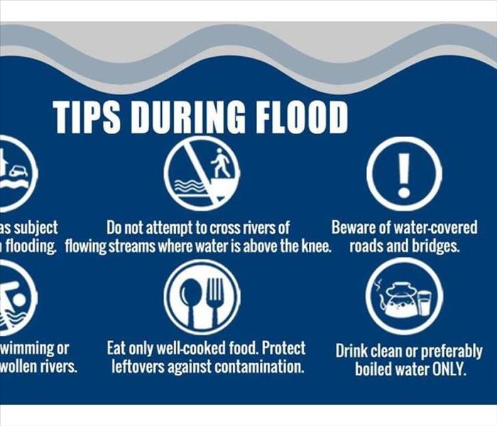
Did you know there are different types of flood events. They are all dangerous yet all come with very different types dangers. Knowing where you live and the type of flood your family and home could be subjected too is essential in how you prepare for them. Zurich insurance put a wonderful article about the various types of flood for you to assess.
To plan for floods, you need to understand the type - or types - of flood you may face. Each one bears a different impact in terms of how it occurs, how it is forecast, the damage it causes, and type of protection you need.
Fluvial floods (river floods)
A fluvial, or river flood, occurs when the water level in a river, lake or stream rises and overflows onto the surrounding banks, shores and neighboring land. The water level rise could be due to excessive rain or snowmelt.
The damage from a river flood can be widespread as the overflow affects smaller rivers downstream, which can cause dams and dikes to break and swamp nearby areas..
To determine the probability of river flooding, models consider past precipitation, forecasted precipitation, current river levels, and well as soil and terrain conditions.
The severity of a river flood is determined by the duration and intensity (volume) of rainfall in the catchment area of the river. Other factors include soil water saturation due to previous rainfall, and the terrain surrounding the river system. In flatter areas, floodwater tends to rise more slowly and be shallower, and it often remains for days. In hilly or mountainous areas, floods can occur within minutes after a heavy rain, drain very quickly, and cause damage due to debris flow.
To determine the probability of river flooding, models consider past precipitation, forecasted precipitation, current river levels, and well as soil and terrain conditions.
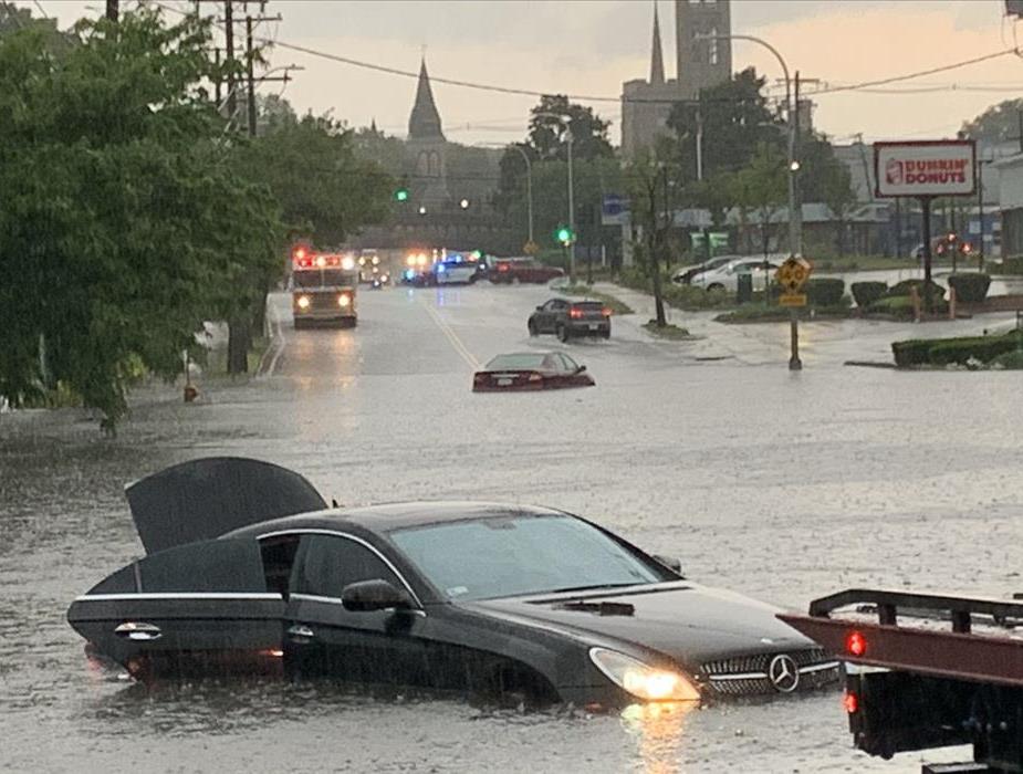
Pluvial floods (flash floods and surface water)
A pluvial flood occurs when an extreme rainfall event creates a flood independent of an overflowing water body. A common misconception about flood is that you must be located near a body of water to be at risk. Yet pluvial flooding can happen in any location, urban or rural; even in areas with no water bodies in the vicinity. There are two common types of pluvial flooding:
- Surface water floods occur when an urban drainage system is overwhelmed and water flows out into streets and nearby structures. It occurs gradually, which provides people time to move to safe locations, and the level of water is usually shallow (rarely more than 1 meter deep). It creates no immediate threat to lives but may cause significant economic damage.
- Flash floods are characterized by an intense, high velocity torrent of water triggered by torrential rain falling within a short amount of time within the vicinity or on nearby elevated terrain. They can also occur via sudden release of water from an upstream levee or a dam. Flash floods are very dangerous and destructive not only because of the force of the water, but also the hurtling debris that is often swept up in the flow.
Coastal flood (storm surge)
Coastal flooding is the inundation of land areas along the coast by seawater. Common causes of coastal flooding are intense windstorm events occurring at the same time as high tide (storm surge), and tsunamis.
Storm surge is created when high winds from a windstorm force water onshore — this is the leading cause of coastal flooding and often the greatest threat associated with a windstorm. The effects increase depending on the tide - windstorms that occur during high tide result in devastating storm surge floods. In this type of flood, water overwhelms low-lying land and often causes devastating loss of life and property.
The severity of a coastal flood is determined by several other factors, including the strength, size, speed, and direction of the windstorm. The onshore and offshore topography also plays an important role. To determine the probability and magnitude of a storm surge, coastal flood models consider this information in addition to data from historical storms that have affected the area.
Below you will find a link not including 2020 as we are still running through the list of named storm for the seasons. We are currently in one of the most active seasons in recorded history.
https://www.usgs.gov/mission-areas/water-resources/science/historical-flooding?qt-science_center_objects=0#qt-science_center_objects
This
Guardian Article.
https://www.theguardian.com/environment/2018/mar/21/flooding-and-heavy-rains-rise-50-worldwide-in-a-decade-figures-show
Zurich Article
https://www.zurich.com/en/knowledge/topics/flood-and-water-damage/three-common-types-of-flood
Image Used from
https://www.masslive.com/weather/2020/06/holy-flash-flooding-massachusetts-residents-share-photos-of-golfball-sized-hail-lightning-strikes-and-street-flooding-from-sunday-night-storm.html
2020 hurricane season in full force
9/22/2020 (Permalink)
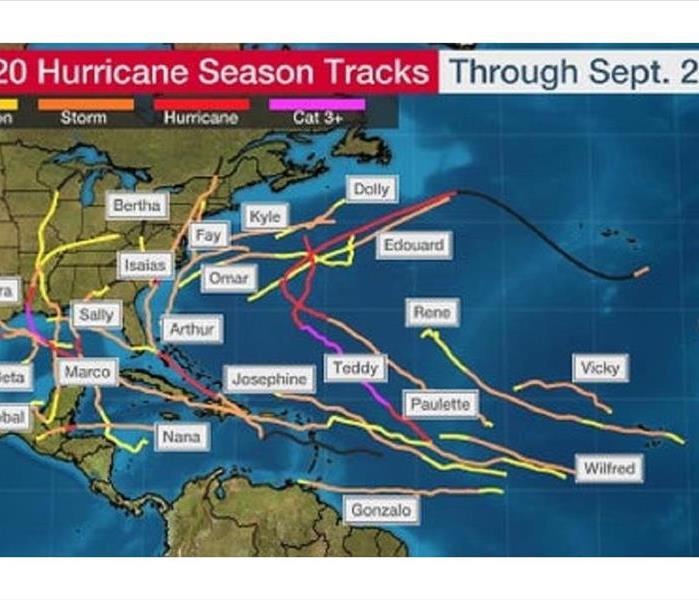 We are in unprecedented hurricane season with some of the strongest storms ever to hit land & possibly the largest number of named storms
2020 is shaping up to quite the year. Not only from the infamous Covid-19 virus but the weather has us all a bit on edge. The challenge of facing this virus outside of the safety of your own home can be daunting.
There have been more named storms during this season than any, other than the 2005 season where they ran out of letters and actually got to Zeta in the Greek alphabet. This season has produced some of the strongest storms ever to make landfall.
USA today had an article back in June in which Rachel Cleetus, also of the Union of Concerned Scientists, said that even without the pandemic, this "would be a challenging hurricane season," due to the predicted number of storms. It really positioned the nation’s ability to keep people safe to be severely tested, she added, and in large part depends on how well FEMA and state and local authorities work together under these unprecedented circumstances.
FEMA said it's ready for hurricane season: "While FEMA continues to lead federal operations during the whole-of-America's COVID-19 response, we continue to take deliberate and proactive steps to respond to and recover from future disasters, such as hurricanes, while responding to COVID-19."
Nursing homes are at particular risk during a hurricane, according to Weather.us meteorologist Ryan Maue.
"(What's) very important during hurricane season is to prepare those in elderly housing including nursing homes for potential storm impacts," he said. "This is just one of many areas where the coronavirus pandemic and hurricane season intersect."
Cleetus pointed out that hurricane season lasts until Nov. 30, and public health experts are warning of a surge in infections later this year.
"We're not out of the woods in terms of the public health challenge," she said.
At the American Red Cross, Trevor Riggen, senior vice president of disaster services, said, "disasters won’t stop during the coronavirus outbreak – so as we head into hurricane season, our goal is to provide anyone in need after a disaster with comfort and support."
He added that amid the coronavirus crisis, Red Cross will provide some relief services virtually, including mental health support and financial assistance, thanks to investments in items like laptops, wireless hotspots and mobile devices.
"Instead of opening shelters, we’re prioritizing individual hotel rooms or dormitory style rooms to make sure people have a safe place to stay if they can’t return home after a disaster," Riggen said.
Know where your loved ones are, understand the plan if and when disasters strike. Being prepared is your best defense.
As the enclosed article by popular science states we are in a very active pattern and it is not done with us yet.
The frighteningly active hurricane season is continuing to live up to meteorologists' predictions. Just a few weeks after Hurricane Laura—the strongest storm on record to make landfall in Louisiana—brought devastating storm surges and rainfall to the Gulf Coast, there are now five more named storms in the Atlantic. The last time this many storms occupied this area was 1971, when there were six storm systems that were tropical depressions or greater.
Hurricane Sally is now a Category 1 storm, but is expected to bring a “historic flood event” to coastal Alabama and the western Florida panhandle. Though the storm isn’t as ferocious in terms of wind speed, it’s moving slowly. Hurricanes that inch along can actually bring more destruction as they hover over an area, dumping immense amounts of water in one spot. The governors of Alabama, Mississippi, and Louisiana have all declared states of emergency.
Hurricane Paulette made landfall in Bermuda On Monday, and will likely peter out over the open ocean in the coming days. Tropical storms Teddy and Vicky are still out in the middle of the Atlantic. Teddy is likely to strengthen as it heads towards Bermuda, while Vicky is expected to dissipate by the end of the week. There’s also a tropical depression and an area to watch off the western coast of Africa.
The 2020 hurricane season has been staggeringly active. We are already at V on this year’s list of storm names. We previously reached this point with Hurricane Vince in 2005, but that’s the only other time since record-keeping began in 1851—and we’re 25 days ahead of that record. Hurricane season stretches into November, which means we have at least another month of storms.
At this rate, we’re likely to run out of names. The only other season in which that happened was, again, 2005. Our current naming system is run by the World Meteorological Organization, which keeps a list of names to cycle through in each storm basin. Here in the Atlantic we have one list, but storm systems in the Indian Ocean have their own names to work through, as do those near Australia and in different parts of the Pacific.
There’s currently just one left to use in the Atlantic basin—Wilfred—since the list of names doesn’t actually encompass all 26 letters. Should we run out of names, we’ll move on to the Greek alphabet. In 2005, we got through to Zeta (the sixth letter of the Greek alphabet), since there were a record-breaking 27 named storms. (Yes, this is a confusing system.)
The original prediction for this year was some 19 to 25 named storms, but so far we seem to be outpacing the most active Atlantic hurricane season on record.
To top it off, smoke from the fires on the west coast are drifting out east and are likely to get wrapped up in Paulette.
Hurricane seasons like this—and intense, slow-moving storms in particular—are only more likely to occur as our planet warms. We now have studies that confirm the fact that hurricanes are becoming more destructive as the ocean heats up, providing more fuel for storm systems. In addition to having more people living on the coasts than ever before, the hurricanes themselves are getting stronger. If we do nothing to slow or halt the climate crisis, our future is going to have a lot more hurricane seasons like this one.
USA Today Article
https://www.usatoday.com/story/news/nation/2020/06/01/hurricane-season-2020-coronavirus-may-cataclysmic-scenario/5274713002/
Popular science Article
https://www.popsci.com/story/environment/five-hurricanes-atlantic-2020-season/
Image from Weather.com article
2020 has been a doozy hurricane season could be too
6/29/2020 (Permalink)
 Hurricane season is set to be busier than normal. NOAA has their annual report and we could be in for a ride.
SERVPRO of East Boston Strives to be your premier source for not only water and fire damage restoration but up to date information on possible upcoming weather forecast for the year.
With 2020 having already been quite the unpredictable one already. The planet has seemingly been one high weather event after another. Below you will find the NOAA weather predictions for the upcoming year that is just getting started.
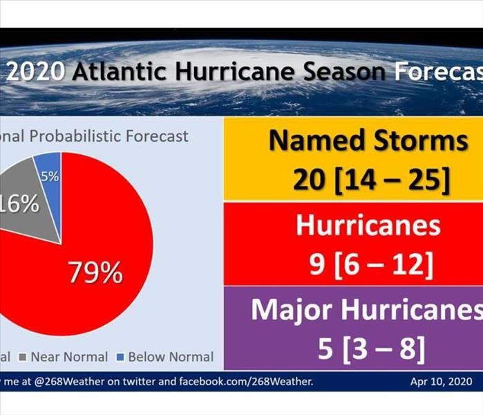
The 2020 Atlantic hurricane season is predicted to be more active than usual, according to an outlook released Thursday by NOAA’s Climate Prediction Center, a division of the National Weather Service.
The NOAA outlook calls for 13 to 19 named storms, six to 10 hurricanes and three to six major hurricanes – one that is Category 3 or higher (115-plus-mph winds) on the Saffir-Simpson Hurricane Wind Scale.
This forecast is above the 30-year (1981-2010) average of 13 named storms, seven hurricanes and three major hurricanes.
NOAA's outlook is in agreement with that released in April by The Weather Company, an IBM Business, which calls for 18 named storms, nine hurricanes and four major hurricanes.
Numbers of Atlantic Basin named storms (those that attain at least tropical or subtropical storm strength), hurricanes and hurricanes of Category 3 or higher intensity forecast by NOAA, Colorado State University and The Weather Company, an IBM Business, compared to the 30-year average (1981 to 2010).
Though the official Atlantic hurricane season runs from June through November, storms can occasionally develop outside those months. This was the case earlier in May when Tropical Storm Arthur formed, as well as the past five seasons with Subtropical Storm Andrea in May 2019, Tropical Storm Alberto in May 2018, Tropical Storm Arlene in April 2017, Tropical Storm Bonnie in May 2016, Hurricane Alex in January 2016 and Tropical Storm Ana in May 2015.
Arthur is included in NOAA's tally of the 13 to 19 named storms it expects this season.
(MORE: What the Most Active Atlantic Hurricane Seasons Have Delivered in June, or Earlier)
NOAA's outlook is based on a number of climate factors, including the El Niño-Southern Oscillation (ENSO) and sea-surface temperatures in the Atlantic Basin.
ENSO conditions are expected to remain either neutral (neither El Niño nor La Niña) or trend toward La Niña, which means El Niño will not be present to suppress hurricane activity.
Additionally, warmer-than-average sea-surface temperatures in the tropical Atlantic Ocean and Caribbean Sea, combined with reduced wind shear – the change in wind speed and/or direction with height – weaker trade winds in the tropical Atlantic and an enhanced west African monsoon all increase the odds of an above-above hurricane season.
Similar conditions have been producing more active seasons since the current high-activity era began in 1995, NOAA said.
For example, 2010 tied for the third-most-active Atlantic hurricane season on record for named storms, with 19, 12 of which became hurricanes. 2017 was the fifth-most-active season, with 17 named storms and 10 hurricanes, including major hurricanes Harvey, Irma and Maria.
"NOAA’s analysis of current and seasonal atmospheric conditions reveals a recipe for an active Atlantic hurricane season this year," said Dr. Neil Jacobs, acting NOAA administrator. "Our skilled forecasters, coupled with upgrades to our computer models and observing technologies, will provide accurate and timely forecasts to protect life and property."
While you should prepare for hurricane season every year, it is critically important to do so this year.
"As Americans focus their attention on a safe and healthy reopening of our country, it remains critically important that we also remember to make the necessary preparations for the upcoming hurricane season," said Secretary of Commerce Wilbur Ross. "Just as in years past, NOAA experts will stay ahead of developing hurricanes and tropical storms and provide the forecasts and warnings we depend on to stay safe."
NOAA’s outlook is for overall activity expected during the hurricane season and is not a landfall forecast. It will update the 2020 seasonal outlook in August prior to the historical peak of the Atlantic season.
Here are some questions and answers about what this outlook means.
What Does This Mean for the United States?
There is no strong correlation between the number of storms or hurricanes and U.S. landfalls in any given season. One or more of the 13 to 19 named storms predicted to develop this season could hit the U.S. or none at all. That's why residents of the coastal U.S. should prepare each year no matter the forecast.
A couple of examples of why you need to be prepared each year occurred in 1992 and 1983.
The 1992 season produced only six named storms and one subtropical storm. However, one of those was Hurricane Andrew, which devastated South Florida as a Category 5 hurricane.
In 1983, there were only four named storms, but one was Alicia. The Category 3 hurricane hit the Houston-Galveston area and caused almost as many direct fatalities there as Andrew did in South Florida.
In contrast, the 2010 Atlantic season was quite active, with 19 named storms and 12 hurricanes. Despite the high number of storms that year, no hurricanes and only one tropical storm made landfall in the U.S.
In other words, a season can deliver many storms but have little impact, or deliver few storms and have one or more hitting the U.S. coast with major impact.
Named storm tracks in the 2019 Atlantic hurricane season. The colors correspond to intensities of each named storm during that section of the track, except for the black sections, which correspond to either a remnant or the time during which a system was a tropical wave before forming into a depression or storm.
The U.S. averages one to two hurricane landfalls each season, according to NOAA's Hurricane Research Division statistics.
In 2019, there were two U.S. hurricane landfalls – Barry in Louisiana and Dorian in North Carolina.
(MORE: Why 2019's Hurricane Dorian Wasn't Retired by the World Meteorological Organization)
In 2018, four named storms impacted the U.S. coastline, most notably hurricanes Florence and Michael within a month of each other.
In 2017, seven named storms impacted the U.S. coast, including Puerto Rico, most notably hurricanes Harvey, Irma and Maria, which battered Texas, Florida and Puerto Rico, respectively.
(MORE: Three Category 4 Hurricanes Made a U.S. Landfall in 2017)
Before that, the U.S. was on a bit of a lucky streak.
The 10-year running total of U.S. hurricane landfalls from 2006 through 2015 was seven, according to Alex Lamers, a meteorologist at the National Weather Service. This was a record low for any 10-year period dating to 1850, and considerably lower than the average of 17 per 10-year period in that same span.
None of the U.S. landfalls from 2006 through 2015 were from major hurricanes.
So it's impossible to know for certain if a U.S. hurricane strike will occur this season. Keep in mind that even a weak tropical storm hitting the U.S. can cause major impacts, particularly if it moves slowly and triggers flooding rainfall.
How Much of a Role Will El Niño or La Niña Play?
El Niño/La Niña, the periodic warming/cooling of the equatorial eastern and central Pacific Ocean, can shift weather patterns over a period of months. Its status is always one factor that's considered in hurricane season forecasting.
As of late spring, neither El Niño nor La Niña were in place. NOAA forecasts a 65% chance of these neutral conditions continuing during the summer ahead.
Long-range forecasters at both The Weather Company, an IBM Business, and Colorado State University were generally in agreement with NOAA, suggesting that neutral conditions are anticipated through at least the first half of the hurricane season (June through August, or JJA), with either neutral or La Niña conditions possible in the second half (September through November, or SON).
We should note here, before talking about the impacts of a possible La Niña, that the status of the El Niño-Southern Oscillation (ENSO) is notoriously difficult to predict. This is especially true from February to May, when the "spring predictability barrier" is in play, a period when forecast skill is lower than the rest of the year.
La Niña generally acts as a speed boost to the Atlantic hurricane season, but it is just one factor that can lead to an active year. Hurricane seasons can be active even if La Niña is not in play.
La Niña typically corresponds with a more active hurricane season because the cooler waters of the Eastern Pacific Ocean end up causing less wind shear along with weaker low-level winds in the Caribbean Sea. La Niña can also enhance rising motion over the Atlantic Basin, making it easier for storms to develop.
The La Niña years of 2010 and 2011 are among several tied for the third-most-active Atlantic seasons on record (both years had 19 named storms). The next La Niña year, 2016, was also active, with 15 named storms that included Category 5 Matthew and three other major hurricanes. La Niña conditions recurred midway through the hyperactive and catastrophic 2017 season that produced Harvey, Irma and Maria.
Other Factors in Play
One of the other ingredients that meteorologists, including those at NOAA, are considering for hurricane season is current sea-surface temperatures across the Atlantic Ocean.
Much of the Atlantic's waters are already warmer than average as of late May. The Gulf of Mexico is also several degrees above average, given the hot temperatures and lack of rain over the Southeast earlier in the spring.
But it isn't ocean temperatures in April that will help boost or curtail tropical systems; rather, it is water temperatures during the hurricane season.
Climate models suggest that most of, if not the entire, Atlantic Basin will be warmer than average during the peak of the hurricane season.
Forecast Sea-Surface Temperature Anomalies for August through October 2020
(Levi Cowan/TropicalTidbits.com)
An above-average number of tropical storms and hurricanes is more likely if temperatures in the main development region (MDR) between Africa and the Caribbean Sea are warmer than average. Conversely, below-average ocean temperatures can lead to fewer tropical systems than if waters were warmer.
Assuming atmospheric factors are favorable, warmer waters in the MDR allow tropical waves – the formative engines that can eventually become tropical storms – to get closer to the Caribbean and the U.S.
The prevalence of wind shear and dry air across the Atlantic will also need to be watched over the next six to eight months.
If neutral or La Niña conditions do lock in, as most forecasters expect, and the atmosphere responds to it, there could be less wind shear and more favorable conditions for hurricane growth toward the end of the season.
How much dry air rolls off the coast of Africa will also need to be monitored. Even if water temperatures are very warm and there is little wind shear, dry air can still disrupt developing tropical cyclones and even prohibit their birth.
Hurricanes need a precise set of ingredients to come together in order for them to fester, and those ingredients will need to be monitored this year.
The Atlantic hurricane season officially begins June 1 and runs through Nov. 30. This article provides a list of potentially life-saving tips to help you prepare for a hurricane.
The Weather Company’s primary journalistic mission is to report on breaking weather news, the environment and the importance of science to our lives. This story does not necessarily represent the position of our parent company, IBM.
The Weather Company’s primary journalistic mission is to report on breaking weather news, the environment and the importance of science to our lives. This story does not necessarily represent the position of our parent company, IBM.
Frostbite and Hypothermia.. What Is It and How to Stay Safe
1/2/2019 (Permalink)
 Frostbite and Hypothermia can take its toll. It can come on quickly and many do not notice. Please pay attention to the early warning signs.
Frostbit and Hypothermia safety
It is New England and while the weather so far this season has lent itself to being a mild one we are not out of the woods yet. Typically a mild December lends itself to wild weather at the end of January and February. Many days have allowed those die hard New Englanders to continue to tough it out with shorts and tee shirts. That being said it is a good time for a reminder about how quickly our weather can change and what you can expect in the new two coming months.
Frost bite.
This is a very big concern that many all too often through caution to the wind. We wear the shorts, do not use the gloves, grab the flip flops and socks (WHY WHY JUST WHY), those high fashion shoes that go with your outfit that you cannot even walk on and if it is not a baseball hat who needs it. Well you do!! We have had a lot of wind this season. The wind takes those mild temperatures we have had and drastically alters them. The wind pushes the air allowing it to move through clothing easier. It also brings the real feel temperature down. If you do not have the right clothing. When you are trying to look a part you run the risk of some very severe consequences.
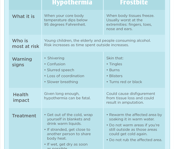
What is frostbite and how to tell if you have it.
There are two stages to frostbite Superficial frostbite and traditional frostbite. With any frostbite the extremities are more susceptible. Fingers, toes, nose, ears, cheeks, and chins. Some of the first indicators of frostbite are extremities start to turn red. You may also have a feeling of pins and needles in the area being affected by the cold. It can start to sting, burn or even become itchy. Looking at the color is essential it can initially be red but will start to turn gray or white maybe even a little yellow looking as the tissue becomes more damaged. If you do not rectify these issues soon enough and in the right way your skin may start to become hard and feel waxy as the cold gets into the deep parts of the tissue. Blisters may start to form especially you try to warm up the affected area the improper way.
What you should do if you suspect you are getting frostbite. First and foremost get out of the cold. Get any wet clothes off, and also get any jewelry off as it will be cold. You can put the affected area into warm water between 100-105 degrees to warm it up slowly. You can also individually wrap the area with a gauze. If your hands or feet were affected it is important that you wrap each one separately. If you are unsure about how your feeling always check with a professional and seek out emergency help right away. Once color changes start to set in you can have permanent damage up to and including amputation.
Hypothermia
This type of issue is much more drastic and affects the entire bodies core temperature when the core temperature drops to 95 and below is when trouble starts. The body tries to protect itself but routing blood to vital organs and extremities. This can result in a dangerous situation. As with any uncertainty it is imperative to seek out professional medical assistance. Until that happens there are steps you can take to help the person. Remove any wet clothes, get them into a warm environment. Surround them with warm layers of blankets and pillows for insulation. Make sure you are covering feet, hands, arms, head. It is also important to lay them down to make sure that the blood can flow easily and reduces how hard the heart has to work to move the blood around. Do not move anyone suspected of hypothermia too quickly because they are more susceptible to a cardiac event. Should something happen CPR may need to be administered until help arrives.
There are 3 stages of hypothermia they are all based on the ambient temperature of the body.
Mild: 90-95 degrees: The body tries to protect itself by increasing rate of breathing to pull in more oxygen to improve blood flow. It will also start to make you feel tired and fatigued so that major organs get more care. Blood pressure will tend to rise and shivering will commence. Coordination and judgment will begin to be impaired.
Moderate: 82.4-90 degrees: At this stage the blood pressure tends to start falling, your reflexes are more affected. Breathing heart rate and coordination become more labored and more difficult.
Severe: Less than 82.4 degrees: This is a highly critical stage in which breathing is much more difficult as the body tries to protect the brain. Your pupils will become less reactive heart attacks and full heart failure are more predominant at this point. Risk for a pulmonary edema is likely at this point.
Keep an eye out for any of these issues and try to get into a warm safe place as soon as possible. Once memory becomes impaired there is a tendency and desire to remove clothes. They can become combative and irrational.
While we are hardy New Englanders we can be too hardy and stubborn at time. The desire to look fashionable and show we can handle the cold. This can prove to have dire consequences. Please pay attention to the weather, include the wind chill in your assessment, stay alert (you are not being a baby), be smart. Making winter fun requires a little bit of safety awareness.
Summer Storms in New England
7/26/2018 (Permalink)
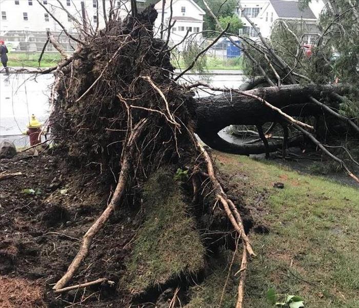 Trees who had a dry summer and suddenly become saturated have nothing to hold them in place
In New England we tend to think of storms being something that we need to worry about during our harsh winters. The storms that swept through Upton, Douglas and other western MA we are reminded we are not 100 % safe from the raging storms of the summer.
There are some key things that you can do to protect your home that will last through out the year.
Insurance Coverage
If you are the homeowner or a renter. it is important to start with your insurance coverage. Renters you need to have renters coverage because a home owner is not responsible for your stuff. Home owners make sure you have the right coverage for your property based on the area. This will be the catalyst for what will be covered and what will not be covered. For example, if you are in an area prone to flood but not an official flood zone it may make sense to get flood coverage for example and want to reach out to your agent and review your policy. Coverage options for the structure and contents is also two different things. That too may be something worth looking into. If you have any valuables that would be over and above a specific value such as jewelry check your policy. They have the limits on these types of items unless there is a stipulation otherwise. Having proper documentation along with proper coverage is essential for getting you back to normal as fast as possible.
Air Conditioners
Not that many of us needed to be told this but according to the National Weather Service, there is a 50 percent to 60 percent chance New England could experience higher-than-normal temperatures this summer. A lot of us have bought air conditioners that have never used them before. Maybe even added one to another part of the house. Check which outlets are connected as older wiring that is found throughout New England may have more units connected than you think. Having more than one large draining device can cause fires.
Check your Gutters
The run off water from your roof has to be directed away from your home. If it is safe to do so check your gutters or hire a professional to keep them clean and free from debris. There are covers that can be put over the top to aid in the long term. Again while you are out walking around check out your roof look for any warped or have any holes. Use a garden hose and empty water to the gutter system to see if you have any leaks in the seams or corners of your gutters. Make sure you check all of the elbows and down spouts for any large items or accumulation of debris. These clogs can cause the water to back up into your home. Using extenders on the bottom of the down spouts to direct the water away you’re your home and route it safely to a place where it will not collect.
Look at those trees
Are any branches touching the house? Does it look like the trees have leaned more towards your home than they were before. Trees can twist in the wind look up where large branches diverge from the stem. Inspect them from the ground and if you are questioning them at all call a specialist and put the wheels in motion. Due diligence is an imperative part of being a home owner.
Use generators safely
Here in New England we should be familiar with the use of generators. Yet we feel the need to remind those using them for a power outage in the summer is no different than using them in the winter. They need to out in the open. Away from the house out of garages. Do not put them on porches or near any open vents, doors or windows. It is also important to keep the fuel that you use to power it away from it unless it is off and being refueled. Depending on how it is fueled or its type will determine if it needs to be professionally installed and grounded or just plugged in. Be in the know before you need it so it is ready when you do.
Protect against Lightening
Did you know that you can get a surge protector (yes like the ones you have all your electronics plugged into) for your house. It is a whole home surge protector. It is installed by an electrician directly to your electrical panel. Each outlet can have its own surge protector those are the strips as well depending on what the home size is and what your goals and budget are.
Developing a plan now for the storms and unsettled season that we seem to be having is going to be pivotal to how well you get through any difficulties that arise. Preparedness is something we strive to achieve and help our clients achieve as well.
Roofs, Gutters, Snow and Rain do not mix......
1/11/2018 (Permalink)
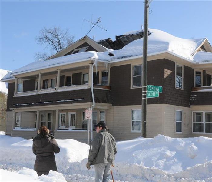 Clearing the snow off the roof and shoveling out the down spouts to your gutters and sewer drains is going to help with all the rain coming to Boston
Having a hard time shoveling/Walking/ driving with all the ice and snow in and around Boston???? Yes we know you are we see the posts..
It is heavy.. Hard to move. .Frozen solid.. Sidewalks not shoveled///
OK so it is warming we are all looking forward to it... We are in the clear.. Its going to rain and be almost 50 right..... Ummmm No not even close..GET THOSE ROOFS SHOVELED OFF BEFORE IT RAINS and clean out those down spouts so the water has somewhere to go. This is very important because behind this rain will be another blast of cold air which means more freezing. Even measurable icing event behind the rain.
Did you know.
Total accumulated weight: 2 feet of old snow and 2 feet of new snow could weigh as much as 60 lb per square foot of roof space, which is beyond the typical snow load capacity of most roofs. Ice: 1 inch of ice equals 1 foot of fresh snow.
Do you have icicles hanging from your roof?
Do you have snow on your roof?
Do you have gutters?
Are the downspouts blocked by snow?
If you answered yes to any one of these questions you have a major problem on your hands.
Ice causes melting snow to stop up and back up onto your roof and possibly into your home. If not it will stay and create more ice. If it gets under a shingle , breaks your gutter off or even cracks a corner of your home you will have a major water problem in your home most likely between the walls. Icicles also mean heavier water on your roof.
If you still have measurable snow with the temperatures warming up you will most likely see some rapid melting provided you have a good drainage system with no ice. ( but hey we have only had -25 wind chills I am sure you don't have ice hahah) You will be fine.
We have a major rain event set for Friday.. with excess of 2.5 inches of rain on the way. Couple that with the snow already on roofs with little or any place to go. You are at risk for a roof collapse
Got Gutters?????
We talked about roof shoveling and it’s importance. Did you get it done? Hope so because now you have more work to do. Snow on roofs..sidewalks and streets are frozen and making a mess of walking and getting around. We know we have seen all the issues online...
We all have to look out for one another as well as ourselves from time to time. Relying on the city, a business or a landlord to do something does not always work law or otherwise.. As we have seen. Let’s all help out this was a bad storm with another on the way.
Find your gutters ... the down spouts are buried by all the snow that we got or got put out of the way. GUESS WHAT....Its in the way.
We are getting 2-3 inches of rain it needs a place to go.
Storm drains are blocked by snow..
Gutters are totally covered.
Sidewalks and streets have solid bricks of snow encased in ice.
Open up a drain If it is in front of your house
Shovel out the down spouts ALL of them
If you don’t that water is going to flood into homes
If you do not have flood insurance this will not be a covered event. A little bit of shoveling is worth it trust me. Even if you do it is very limited so just get it done. Landlords are tapped out. City’s are over extended. Complaining will not stop the water from coming Friday let’s just get this done.
Nor'Easter
1/2/2018 (Permalink)
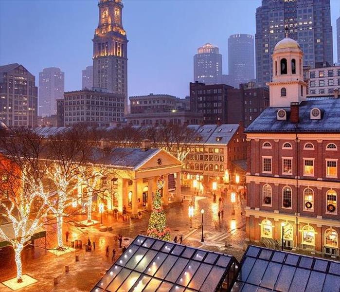 Boston looks picturesque at this height during this time of the year. However the bitter cold sets in and a Nor'Easter this view changes quickly
Did you know that MA has a website that can provide you with emergency information and assistance on how to find help. I know right who knew?
http://mass211.org/
From here you can get a lot of information fast and accurate. Should you need help during this intense record breaking winter season here in New England.
Record breaking cold rounded out our 2017 year bring it all into the start of 2018. Creating havoc. Our aging water systems pipes cannot handle the frigid temperatures and have had more water main breaks than we care to talk about. There have been gas line fires, house fires started from people trying to keep warm and improperly using space heaters. There have been some unintelligent uses of blow torches, as well as pipes bursting. We know there are a lot of ice dams on peoples roofs we can see them, but no one has called us for damage yet because they are not melting very fast due to the cold but they will.
Being prepared and knowing what the forecasts are saying is your only way to stay ahead of everything this season. There are numerous ways to stay informed and up to date. Below is a link for choosing the right way for you to receive your information. There are even apps that you can download to your phone.
https://www.weather.gov/subscribe
Did you know that preparing for a Nor’Easter is almost the same as preparing for a hurricane. Yes it can be that serious. Having a weather app on your phone to listen for updates is the first step to being in the know. Ensuring your car has plenty of gas so that if you lose heat or power you can at least be warm until you make other arrangements. . Making sure your phone is charged before you lose power is key, and having a car charger will help keep you in the loop while you search out your options.
Know where the warming stations in your town are and being prepared to leave with your family to go to them if necessary. Many town buildings like libraries have opened their doors to those who need it . There are a number of local churches and shelters that have extended capacity to make sure everyone that needs it will have a place to go. So do your research on that now.
Alternative and additional heat sources. Yes we know that it is cold and the house may be drafty so what do you do. Crank up a wood stove or fire place if you have it. Great but please be safe, clean and empty the ashes into fireproof tins and outside on a non flammable surface (NOT YOUR PORCH). So you have a space heater, wonderful, are you following the 3ft rule? Not sure what that is keep everything 3ft away yes everything clothes, furniture, curtains, kids, pets, rugs everything. Oh and for the sake of good sense only directly plug them into wall units.
Food preparedness: With the cold of the winter we have a bit of a reprieve than what we do in the summer. If you are out for more than 4 hours get your refrigerator cleaned out and put it all outside on the porch in containers this will ensure you do not lose any of that food. The freezer would be a good idea to but if you get the power on before the 8 hour mark that stuff should be ok. Also make sure you have some foods that are non-perishable and that you have extra food on hand for your pets. It could be a while until you get to a store. Keep an eye on things but remember animals are looking for food this time of the year so make sure the food is in a container and covered.
So you have food taken care of, you have found places to go if necessary, you are getting ready to leave your home for what could be a few days depending on when you get your heat back on. You need to get your home ready. Turn every faucet in the house on and let it run while you are going to be gone. Open all of your cabinets and doors this will let the air circulate and help to try and keep the pipes from freezing.( Hopefully)
Is your Car prepared? There are a few things you should always keep in your car, Shovel, cat litter or sand, extra chargers, blankets as well. Flashlights, knife, jumper cables road maps (yes the paper ones), an extra set of clothes and some drinking water and food. These are just the basic suggestions depending on how many people, or animals you are going to be with will determine how much you actually need.
Being prepared will help you survive and stay safe during emergency situations. Knowing where to go to get and getting there safely may just save your life. Be in the know and be prepared.
Watch/Warning/Advisory .. What do you know??
12/28/2017 (Permalink)
 Winters in Boston can get pretty intense if you are not prepared you could be in for some trouble. Know the warnings and be ready
WE are in the thick of winter here in New England. With all the weather we have already had we thought it would be a good idea to keep you up to date with all the watches, warnings, and advisories that can be issued. They can be confusing and if you do not know which one is worse you could be in some trouble.
Hazardous Weather Outlook
The Hazardous Weather Outlook will describe potential hazardous weather and hydrologic information of concern in Days 1 through 7.
The outlook contains two segments: One segment for the marine zones and adjacent land-based (i.e., coastal) zones and the other segment for the rest of the land-based zones. Each segment of the HWO will contain 3 sections: short term through Day 1, long term for Days 2-7, and spotter information.
Winter Storm Watch
A Winter Storm Watch is issued when there is the potential for significant and hazardous winter weather within 48 hours. It does not mean that significant and hazardous winter weather will occur...it only means it is possible.
Significant and hazardous winter weather is defined as a combination of: 1) 5 inches or more of snow/sleet within a 12-hour period or 7 inches or more of snow/sleet within a 24-hour period AND/OR 2) Enough ice accumulation to cause damage to trees or powerlines. AND/OR 3) a life threatening or damaging combination of snow and/or ice accumulation with wind.
The snow/sleet criteria for a Winter Storm Watch for the five westernmost counties (Allegany, Mineral, Grant, Pendleton, and Highland) is higher (6 inches or more within a 12-hour period; 8 inches or more within a 24-hour period).
Blizzard Warning
A Blizzard Warning means that the following conditions are occurring or expected within the next 12 to 18 hours. 1) Snow and/or blowing snow reducing visibility to 1/4 mile or less for 3 hours or longer AND 2) Sustained winds of 35 mph or greater or frequent gusts to 35 mph or greater. There is no temperature requirement that must be met to achieve blizzard conditions.
Winter Storm Warning
A Winter Storm Warning is issued when a significant combination of hazardous winter weather is occurring or imminent.
Significant and hazardous winter weather is defined as a combination of: 1) 5 inches or more of snow/sleet within a 12-hour period or 7 inches or more of snow/sleet within a 24-hour period AND/OR 2) Enough ice accumulation to cause damage to trees or powerlines. AND/OR 3) a life threatening or damaging combination of snow and/or ice accumulation with wind.
The snow/sleet criteria for a Winter Storm Warning for the five westernmost counties (Allegany, Mineral, Grant, Pendleton, and Highland) is higher (6 inches or more within a 12-hour period; 8 inches or more within a 24-hour period).
Ice Storm Warning
¼ inch or more of ice accumulation.
Winter Weather Advisory
A Winter Weather Advisory will be issued for any amount of freezing rain, or when 2 to 4 inches of snow (alone or in combination with sleet and freezing rain), is expected to cause a significant inconvenience, but not serious enough to warrant a warning.
If the event is expected to impact the Baltimore/Washington metro areas during rush hours (4-9 am or 2-7 pm on weekdays) forecasted snow totals of one inch will necessitate the issuance of a winter weather advisory. The snow/sleet criteria for a Winter Weather Advisory for the five westernmost counties (Allegany, Mineral, Grant, Pendleton, and Highland) is higher (3-5 inches).
Freeze Watch
A Freeze Watch is issued when there is a potential for significant, widespread freezing temperatures within the next 24-36 hours.
A Freeze Watch is issued in the autumn until the end of the growing season (marked by the occurrence of first widespread freeze). The normal end of the growing season is mid to late October west of the Blue Ridge and early November east of the Blue Ridge. However, during anomalously warm autumns, the growing season may be extended past the normal end of the growing season.
A Freeze Watch is issued in the spring at the start of the growing season (when it is late enough to cause damage to new plants and crops).
Freeze Warning
A Freeze Warning is issued when significant, widespread freezing temperatures are expected.
A Freeze Warning is issued in the autumn until the end of the growing season (marked by the occurrence of first widespread freeze). The normal end of the growing season is mid to late October west of the Blue Ridge and early November east of the Blue Ridge. However, during anomalously warm autumns, the growing season may be extended past the normal end of the growing season.
A Freeze Warning is issued in the spring at the start of the growing season (when it is late enough to cause damage to new plants and crops).
Frost Advisory
A Frost Advisory is issued when the minimum temperature is forecast to be 33 to 36 degrees on clear and calm nights during the growing season.
A Frost Advisory is issued in the autumn until the end of the growing season (marked by the occurrence of first widespread freeze). The normal end of the growing season is mid to late October west of the Blue Ridge and early November east of the Blue Ridge. However, during anomalously warm autumns, the growing season may be extended past the normal end of the growing season.
A Frost Advisory is issued in the spring at the start of the growing season (when it is late enough to cause damage to new plants and crops).
Wind Chill Advisory
A Wind Chill Advisory is issued when wind chills of -5F to -19F are expected east of the Blue Ridge Mountains, and when wind chills of -10 to -24F are expected along and west of the Blue Ridge Mountains and in Frederick and Carroll Counties in Maryland.
Wind Chill Warning
A Wind Chill Warning is issued when wind chills of -20F or lower are expected east of the Blue Ridge Mountains, and when wind chills of -25F or lower are expected along and west of the Blue Ridge Mountains and in Frederick and Carroll Counties in Maryland.
Courtesy of our friends over at the National weather service. You can visit their website at
www.weather.gov for more information and to stay up to date on the latest weather for your area.
Increase in Storms and Water events in Massachusetts
7/24/2017 (Permalink)
 Having a plan and enacting that plan are two different things. Practice and know how to react follow the advice.
Storms and their frequency are on the rise. In addition so too is the intensity of each event. In the United states there has been a 74% increase in the top tier precipitation events since 1958. Flood events have risen along with this severely altering the environment, wildlife, and financial obligations of cities, towns, and individual residents. With flooding of sewer systems there comes an increase of pollution to fresh drinking water access. Being prepared for these types of events is pivotal.
The areas impacted the most from these rain events has actually been the northern costal and mountainous regions of the country. Areas in Eastern Massachusetts have seen an uptick in rain event days that have more than 2 inches of rain per event. The average rainfall has also seen a 1 to 2 inch increase since the 1970’s. The major Connecticut river basin alone has seen double the heavy rain events over the last 60 years. Most of this rain has occurred from May to September.
This shift has also changed the frequency of coastal storms. The rising sea levels are changing the shape of the coast and what is actually considered the coast. We must all be prepared. These storms are what are known as hurricanes and Nor’Easters. Those alone are not the only threats. Increased intensity of Thunderstorms, tornado frequency and even damaging hail events are on the rise. The structural damage that is caused to homes, cars and the natural environment around you can be catastrophic.
What scientist call the 100 Year flood is now being seen every 60 years or so. By the year 2050 these flood level events will be every 10-20 years. In Boston alone these 100 year flooding events are projected to recur every 1-2 years. For many subsets of Boston such as East Boston which are built up and used to be the harbor flooding is a serious concern. Costal Massachusetts is at high risk due to the rising rain fall and sea levels. We are already seeing an uptick in claims and severity of the claims. If you are not currently in a sanctioned flood zone yet, get flood insurance now. This will grandfather you into the policy. Should your area reclassified you will not have to pay new premiums on rates for the new requirements.
Please be aware and be prepared for these events. Check out our preparedness plans for what to have ready and on hand now so you can be safe later.
https://climateactiontool.org/content/storms-and-floods
Prepare Now...Weather through later.....
3/8/2017 (Permalink)
 Preparing for a disaster is the best way to make it through the disaster. Plan Prepare Persevere
IPAWS…. No it is not a fancy term for a program for pet lovers… it is an Integrated Public Alert and Warning System ( IPAWS)
Created by FEMA, to provide an effective way to get information quickly and accurately out to the public in times of emergencies. It is able to tap into all the major emergency networks such as Emergency Alert System (EAS), National Oceanic and Atmospheric Administration (NOAA) for any weather related problems, Wireless Emergency Alerts (WEA) It is also used to send Presidential, AMBER and imminent threat alerts out. These messages can be sent through one or all of these channels to ensure that everyone that needs to be reached can be.
So what is NOAA.. It is a nationwide network of radio stations broadcasting forecasts, warnings, and emergency information 24 hours a day. It is a comprehensive weather and emergency information service available to the public. All Hazards messages include weather events, technological incidents such a chemical spills, AMBER alerts, and national emergencies. NWR also broadcasts EAS notices. A special radio receiver is required to receive NWR broadcasts. You can buy these receivers at many retail electronic stores, department stores, big box stores or even online. Make sure you are looking for the Public alert or NWR logo to ensure the radio meets the requirements. Models that identify as SAME ( Specific Area Message Encoding) will allow users to select alerts for specific geographic areas. For information on NOAA Weather radio All Hazards visit.
www.nws.noaa.gov
Local Jurisdiction Emergency Notification System:
Many local jurisdictions have an opt-in public alert and warning system. The opt-in systems requires you to sign up in order to receive the alert. Once you have signed up officials in your area can send you a text or email messages about local emergencies. Most opt-in systems all subscribers to choose the devices that receive alerts as well as the type of alerts. You may not be near a television or a radio when something happens a local text or email can be an extremely useful source for critical information. Small costs may be associated with receipt of the text message from your mobile carrier.
To find out what alerts are available in your area you can do a search online with your town, city, or county name and the word “Alerts”: You can go to the website for your local emergency management or public safety office, on contact these officials by phone.
Enhanced Telephone Notification (ETN) Systems;
In the event of an emergency local officials in many communities can send warning messages and instructions to individuals in an at risk areas through the ETN system. Such as a reverse 911 call. Most of these systems involve a land line phone system. At times they will allow a VOIP, and mobile through an opt-in process. So incase you do not have a land line check with local emergency management for information on this feature and its availability.
Out Door Sirens & or Voice Alert Systems
These systems are used to alert people outdoors of an immediate danger so they can take cover. It is not designed to be heard inside buildings or go through walls. Some communities while they have the siren in place it is no longer working. Please check with local officials to see if it is provided in your area.
Local School or Organization Notification Systems:
Many work places, schools, and community & Faith based organizations have systems in place to warn individuals of emergencies and provide tailored notifications to members. They are similar to the systems used but local emergency officials so check with the heads of these organizations and opt-in where you can.
Mobile APPS with Local alert functions.
FEMA APP ( Federal Emergency Management Association)
This will keep you updated on a vast array of emergency updates for up to 5 areas of the United States. There will be tips on how to stay safe, before, during and after over 20 various types of hazardous situations. You can customized it and save information for your families emergency plan. Receive and find driving directions to open shelters for disaster recovery. Submitting photos on the areas affected will help rescures find those most in need and keep tabs on everyone that needs assistance. This can be done through the disaster reporter feature. The app is available in English and Spanish and can be found through ITUNES or Google Play to learn more visit
www.fema.gov/mobile-app
American Red Cross APP
This app contains over 35 different types of severe weather and emergency alerts. You can choose the alerts you want to receive and that are important to you based on your location or that of your loved ones. There is a “Family Safe” feature that allows you to notify others if an alert has been issued in the area as well letting you check to see if they are safe. It also has tips on what to do before a disaster strikes, how to keep yourself safe during and what to do after. It will also keep you update on were Red Cross Shelters will be should you need help. This again is in English and Spanish and be found in either ITUNES or Google Play. To learn more visit…
www.redcross.org/prepare/mobile-apps
The Weather Channel App
This app tracks you guessed it weather and provides local forecasts. It will push out alerts of severe weathers to your mobile device as soon as they happen. This is free on ITUNES or Google Play. It can also be downloaded is APP world for black berry and windows phones at www.weather.com/apps
Recap of actions you can take to be prepared.
Confirm your mobile device can receive Wireless Emergency Alerts
Sign up for text or email alerts from your local jurisdiction
Consider purchasing a NOAA weather Radio All Hazards
If you do not have a land line check to see of your local community has operations set up for VOIP and or mobile phones to be connected to the ETN systems such as reverse 911.
Sign up for listservs and alerts for the workplace, schools, houses of worship or other community organizations you may want to hear from during an emergency
Download all relevant apps for appropriate alerts, hazards or warnings.
Create a list of all the alert systems available to you for your area. Make sure everyone in the household receives the alerts as part of your household communication system.
Organizations:
Test all of your emergency systems regularly to ensure proper working order. Also making sure everyone within the organization can be contacted.
Designate specific individuals to be responsible for distributing alerts from an official source.
Consider getting some NOAA Weather Radio All Hazards.
Develop a list of all the alert systems available for the communities surrounding the areas you service. This is especially important with multiple locations.
Encourage all of your employees to sign up for alerts and warnings. Assist them with finding the necessary information.
America’s PrepareAthon! Is a grassroots campaign for action to get more people prepared for emergencies. Make your actions count.
www.ready.gov/prepare
Storms hit hard are you covered???
12/27/2016 (Permalink)
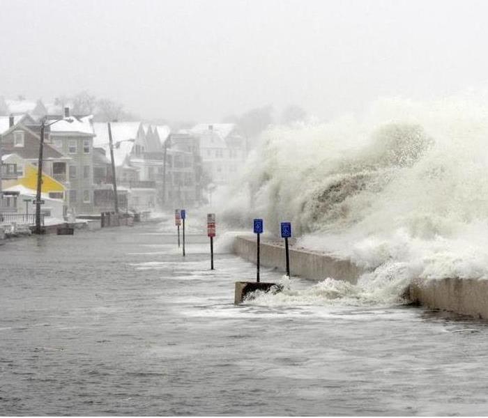 New England Storms vary from Water, Ice, Snow, Fire, and occasional tornado are you ready? Who do you call and are you covered
Storm damage to homes can vary greatly. The kind of storm, where you are located, and what is going on around your home can all impact what goes on.
For example if you live near the coast and there is a storm surge coupled with some high tide serious flooding can be a major concern. This can be amplified if you are on the edge and beach erosion occurs. Many home owners have the bare minimum coverage levels of insurance and if you are not in a flood zone many do not have flood insurance. Guess what this would be classified as a flood and you would not get any assistance with the process of getting back to normal.
Should you live further inland and be surrounded by nature. A strong storm with a lot of wind can be your down fall. A dry winter coupled with some rain will loosen the roots of those large trees that provide you shade in the summer. With nothing solid to hold onto these trees can be easily uprooted and topple over. Should your home be in the way there is a lot of trouble to be had. Many do not have storm damage coverage for such events and will have no assistance getting back to normal .
Storms can also bring heavy wet snow. This snow can sit on a roof or melt. Should it sit a little too long it will become heavy and possibly cause a crack or gap in the roof or foundation that is not able to support the weight. When this happens and then the snow eventually melts which it will a lot of damage can occur. This water will find the path of wet to dry and many time during that search it leads to the inside of your ho me.
If you live in an area of open fields and wide open view of flat land or have a farm. The storms that ravage through could include a tornado. We have all seen the destruction and devastation of those. When a home is flattened or a roof has been ripped off from the wind what is left to protect you from the onslaught of rain damaging your belongings inside. Many time this secondary damage has very limited coverage and will be dependent on the speed in which you called someone about the first part of the damage and their response time. Make sure you are calling a professional that can arrive quickly. Mitigating your response time is doing your part of the insurance process.
Drought while not an actual storm event can lead to devastation and destruction. Many times this dry debris on the ground can be ignited and cause a literal fire storm. Once a fire has started if your home is affected there is a lot to be done. Also an investigation will be conducted to find the cause of the fire. Should that lead to anything malicious it is important to know what is and is not covered. Subsequently if there is a fire in your area but not in your home it does not mean you will not be affected. The odor from a nearby fire can infiltrate your home and cause quite a bit of damage. Ensure you are ready and know if your policy will cover such an event.
Many times if an insurance policy does not say it, It is not covered. That can turn into a major disaster if you are left to fend for yourself during a significant loss beyond your control. It is always wise to review your policy and make sure you have coverage for as much as you can. No one has insurance because they want to and certainly not because they expect to need to use it. Yet finding out you do not have the right coverage when you need it most is not the time to find that out. Call your agent or broker today and make sure that any unforeseen issues are addressed before it is too late
Preparing your home for winter in New England
11/30/2016 (Permalink)
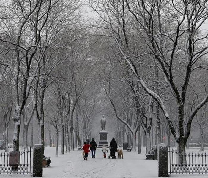 In and around Boston in the winter can be a beautiful. Ensuring your home does not suffer from any storm damage will help you enjoy the season
It is that time of the year again here in New England. Winter storm season. This 2016-2017 season is predicted to be much colder due to a weakened La Nina. NOAAs’ prediction is that the northern states will see a lot more snow than last year. Which was one of the warmest winters in 121 years. This year is predicted to be riddled with frequent storms and cold temperatures.
These colder temperatures and increased chance or more storms mean there could be more storm damage. This damage could be from the cold getting into your homes and freezing your pipes to heavy snow collapsing roofs. Now is the time to prepare and take steps to reduce the chances of damage to your home. Freezing pipe, ice dams and fires are the most common forms of damage during the winter season. Here are some key tips for helping to prevent major problems.
Insulate pipes..
We have said it before and we will say it again get some cheap foam from a home improvement store that rated for the type of water pipes you have. Put them on as many as you can find. Make sure you leave room when you get close to the heating units so that there is no risk of fire.
Open Cabinet doors
When the really deep cold sets in make sure you open cabinet doors. Ensuring under sinks, in bathrooms, cabinets and hutches that have piping running from one level to another are all open will help keep your pipes more warm
Run the water
Yes run the water. A slow moving water drip will help prevent freezing because moving water takes more time to freeze. This is not a full on high running water it is a slow stead stream. Know the difference. Remember that it is one and if you can collect the water and place in front of your heat source so that you can introduce moisture back into your home and conserve a little water in the process.
Search for Gaps
Look at pipes, vents especially dryer vents and electrical outlets that come in from the outside. If there are drafts fill the edges with caulking or spray foam. This will help keep the cold out.
Properly setting your thermostat
Many of you looking to escape the dull gray skies will go on vacation. In an effort to save money so many turn their heat way down or off. ***DO NOT DO THIS*** Keep your thermostat at a minimum of 55 degrees we like 60 or better, and open any and all cabinet doors. The last thing you want at the end of your vacation is to come home to a soaking wet house that has been running for days.
Knowing your home:
Where is your water shut of valve. Sure most of us know how to turn off the water if something happens to the toilet or the washing machine it is the valve right next to it. What about a pipe on the 2nd floor to mitigate your damages. Do you know where the main shut off valve is for the house? How about how to turn off your water heater? Learn where these things are and show everyone who is old enough how to do it as well. The sooner the water is shut off the less damage it can cause.
Ok so your home should be ok now we did not forget about your garden. We love the pops of color in the spring. The Home grown vegetables from the summer and the atmosphere of the leaves in the fall create a home outside for you and your family. It is important to take care of it during the winter months. Sure it will get covered in snow and there is not much you can do but before that happens here are few tips.
- Before the first Frost:
- Any attempt to protect plants should be done before the first frost. You can usually find some information online about your area and when that typically happens.
- Cultivation Protection:
- You can do a variety of things with the plants and their placement to aid in the winterization. Choosing sheltered spots will protect from wind damage and the sudden onset of cold weather. Know the North, South facing spots as well as how much sun these spots get this will aid in placement.
- Mulching
- I know mulching in the winter? It acts as a great insulator and holds a lot of soil from being washed away as the rain and snow move and.
- Planters and containers
- Create a portable garden that you can place anywhere based on the season.
- Special wrapping & Structures
- Insulating wrapping can be obtained to protect susceptible plants to keep the more warm during the freezing temperatures of the winter. Structures can also be built to protect from the heavy weight of the snow and any that could fall off of a roof onto plants near the house. “A” Frames are the easiest and most effective. Creating a windbreak or barrier can aid many plants as well. This can be achieved from other plants such as dense bushes or hedges. You can make one with some netting and posts staked into the ground
- Drainage
- It is important that you do not have pooling water in any areas of your yard. Extra wet soil just like extra dry soil will prevent the roots from holding firm and could have trees uproot. Ensure that your lawn is level and pooling does not occur.
Keeping these things in mind will help you have a worry free winter. Filled with family, friends, and fun. When spring comes you will ready to go with a lot less fuss. Have a wonderful holiday season and enjoy the winter.
Understanding Storms and How to prepare
7/14/2016 (Permalink)
 Storms can be very beautiful but dangerous, deadly and powerful,, Understand them respect them and know how to stay safe when they strike
Storm Basics
A thunderstorm is a rain shower during which you hear thunder. Since thunder comes from lightning, all thunderstorms have lightning. It is classified as “severe” when itcontains one or more of the following:
Hail (one inch or greater)
Winds in excess of 58 mph
Structural wind damage
Tornado:
Tornadoes are arguably nature’s most violent storms. Generated from powerful thunderstorms, and generally appear as rotating, funnel-shaped clouds extending from the cloud base to the ground. With winds that can reach up to 300 miles per hour, tornadoes can cause massive destruction within seconds. Damage paths can be in excess of one mile wide and fifty miles long. The average tornado moves southwest to northeast, but tornadoes have been known to move in any direction. The average forward speed of a tornado is 30 miles per hour, but may vary from stationary to 70 miles per hour. Tornadoes can accompany tropical storms and hurricanes as they move onto land. Tornadoes are most frequently reported east of the Rocky Mountains during spring and summer months. Tornadoes are most likely to occur between 3 p.m. and 9 p.m.
Tornado Facts and Storm Tips (above) are provided by FEMA (Federal Emergency Management Agency).
Watch vs. Warning
A severe thunderstorm watch: means that the potential exists for the development of thunderstorms which may produce large hail or damaging winds. A watch is issued by the SPC (Storm Prediction Center).
A severe thunderstorm warning: means that a severe thunderstorm is occurring or is imminent based on Doppler radar information or a reliable spotter report. A warning is issued by the local National Weather Service office.
Watch vs. Warning and Storm Basics are provided by NOAA (National Oceanic and Atmospheric Administration). For more information visit their website: www.noaa.gov
Be prepared!! Emergency Supply Kit
Recommended items to include in a basic emergency supply kit:
Water (one gallon per person per day)
Food (non-perishable 3-day supply)
Manual can opener
Battery operated radio, preferably a NOAA Weather Radio with tone alert and extra batteries
Flashlight and extra batteries
First aid kit
Whistle to signal for help
Clothing
Dust masks or bandanas
Plastic sheeting, garbage bags and duct tape
Wrench or pliers to turn off utilities
Local maps
Hygiene items
Important documents such as copies of insurance policies, identification and bank account information
Cash
Fire extinguisher
Matches in a waterproof container
Before the storm
To begin preparing, you should build an emergency supply kit and make a family communication plan.
Remove dead or rotting trees and branches that could fall and cause injury or damage during a severe thunderstorm.
Postpone outdoor activities.
Remember the 30/30 Lightning Safety Rule: Go indoors if, after seeing lightning, you cannot count to 30 before hearing thunder. Stay indoors for 30 minutes after hearing the last clap of thunder.
Secure outdoor objects that could blow away or cause damage.
Get inside a home, building, or hard top automobile (not a convertible). Although you may be injured if lightning strikes your car, you are much safer inside a vehicle than outside.
Remember, rubber-soled shoes and rubber tires provide NO protection from lightning. However, the steel frame of a hard-topped vehicle provides increased protection if you are not touching metal.
Shutter windows and secure outside doors. If shutters are not available, close window blinds, shades or curtains.
Unplug any electronic equipment well before the storm arrives.
Use your battery-operated NOAA Weather Radio for updates from local officials.
Avoid contact with corded phones. Use a corded telephone only for emergencies. Cordless and cellular telephones are safe to use.
Avoid contact with electrical equipment or cords.
Unplug appliances and other electrical items such as computers and turn off air conditioners. Power surges from lightning can cause serious damage.
Avoid contact with plumbing. Do not wash your hands, do not take a shower, do not wash dishes, and do not do laundry. Plumbing and bathroom fixture can conduct electricity.
Stay away from windows and doors, and stay off porches.
Do not lie on concrete floors and do not lean against concrete walls.
Avoid natural lightning rods such as a tall, isolated tree in an open area.
Avoid hilltops, open fields, the beach or a boat on the water.
Take shelter in a sturdy building.
Avoid isolated sheds or other small structures in open areas.
Avoid contact with anything metal—tractors, farm equipment, motorcycles, golf carts, golf clubs, and bicycles.
If you are driving, try to safely exit the roadway and park. Stay in the vehicle and turn on the emergency flashers until the heavy rain ends.
Avoid touching metal or other surfaces that conduct electricity in and outside the vehicle.
After the storm
Never drive through a flooded roadway.
Stay away from storm-damaged areas to keep from putting yourself at risk from the effects of severe thunderstorms.
Continue to listen to a NOAA Weather Radio or to local radio and television stations for updated information or instructions, as access to roads or some parts of the community may be blocked.
Help people who may require special assistance, such as infants, children and the elderly or those with access or functional needs.
Stay away from downed power lines and report them immediately.
Watch your animals closely. Keep them under your direct control.
If you have storm damage to your home or property call your local professional immediately. Timely mitigation is key to minimize secondary damages caused by severe storms.
-SERVPRO 1-800-SERVPRO
When the severe storm rolls out ...
we roll in.
Storm Damage .....now what????????
1/14/2016 (Permalink)
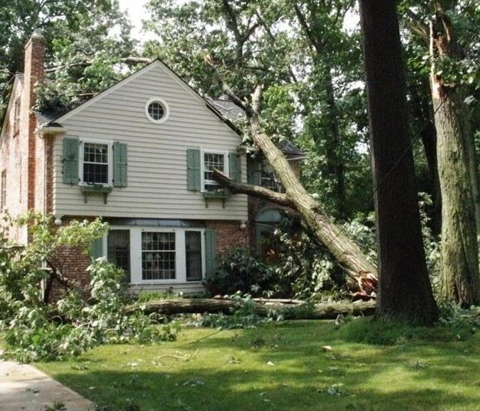 Storm Damage can happen anywhere and be large or small
You have storm damage now what?
Recovery after a storm:
Just because the storm has passed does not mean that the danger is over or that all the damage that is to be done has been done. Continued exposure to the elements can cause further damage and problems. There are some key steps you must take to get back to normal as soon as possible.
Did you know that many insurance companies have time limits on how long you can wait to file a claim? These are very specific time tables and some vary based on the type of policy or even the type of damage that has occurred. Check your policy and know your time frames and make sure when you have a loss that you call the insurance company immediately. When calling the insurance company make sure you are contacting the Claims department directly.
Another good reason to call and get the process started as soon as possible is that the longer your home & Valuables are exposed to the elements the more damage can occur.
We here many people say that they do not call their insurance company because they are worried they will receive a rate increase. This is not the case you cannot be singled out for rate increases due to storm damage when filing an insurance claim. Remember most state laws prohibit insurance companies from cancelling policies for filing claims in an Act of God storm damage situation. In most states insurance company cannot single you out for a rate increase. If the insurance company is going to raise rates, they have to raise everyone's rates in your area. So, if you don’t file a claim, your personal rate increase will pay for everyone else's claim except for yours.
Get a restoration contractor because they have the knowledge with the your specific type of damage but they are also very adept with dealing with insurance companies and will be your best advocate. They will make sure the insurance companies pay for all damage both visible and hidden so that you do not have any major problems down the line.
When you are hiring a contractor there are several tips we suggest. Always get more than one estimate you are not familiar with this sort of work and having multiple estimates will give you a better idea of the true scope of the work that needs to be done. Make sure you are also not basing your decision solely on price. There are many factors to take into account and since most storm damage tends to be insurance work make sure you are picking the best contractor to handle the job. Be aware of any contractor whose pricing is far below as they could be taking short cuts or using inferior products. This can lead to major repairs that may not be covered down the line. Get a minimum of 3 estimates and make sure your entire property was inspected. This inspection should include the roof, windows, siding, AC units, screen, concrete and all exterior surfaces.
Be sure you are documenting the date of the storm itself as well as any time tables as you move through this process this will help to show you are taking proper action. Take pictures of the damage if you can do so safely. If you have any before images of how the property or items looked prior to being damaged these will help not only your contractor but proof of necessary work for the insurance company. Another good idea is to find some news articles about the storm hitting your area set aside in a folder you may need them later.
Make sure you are requesting and insurance adjuster to inspect the property. When scheduling a time for the adjuster to come out make sure you have whomever you have selected at the contractor be present for inspection. The contractor will make sure that the adjuster is noting all of the damage and that they are playing fair when giving you an estimate for the damages. Insurance adjusters work for the insurance companies and if they can find a way to deny your claim they will.
So your claim was denied!!!!!!!!! Breathe it is alright you are entitled to meet with 3 adjusters. Call and request another one. Even small damage should result in some sort of claim approval. Accepting a denial can lead to big problems down the road may be denied for improper action on the initial claim. Just like when you are selecting a contractor the rule of 3 is a good idea.
Once you have gained approval for the claim you will be issued multiple checks one of which will be in your name for the materials make sure the materials are ordered in your name as you will use this check to pay for them and then the contractor can get to work getting you back to normal.
Once the project has been started please make sure that any adjustment changes or deviations made by you or the contractor are submitted in writing and be approved by all involved.
Getting you back to like it never happened is important for you and your family; Make sure there are no headaches along the way make sure you are following the steps above. We hope this helps and remember stay safe out there.


 24/7 Emergency Service